Search This Blog

Popular Posts

Friday, November 16, 2018

My Winter 2018-19 forecast.

I haven't done a video blog to this yet because I am having trouble communicating. But here is my texted forecast. I will share the video shortly for this.

Here is my very detailed forecast.

Because I am a weather guru, I am sharing my forecast for this coming winter. This winter's set up is forecasted to be a weak El Nino what almost ever weather station has said. Now I may be technical in this post so if anything that isnt specified for anyone to understand the term please let me know.

The setup... The weak El Nino like said above most importantly it is forecasted to be an eastern based el Nino. This means the warmer waters above 0.5 degrees Celsius above normal is expected to be near South America compared to its placement. This may set a subtropical jet that may set up over this warmer waters and be over the southern California into the Texas and Misourri area that will then combine with the Artic Jet listed below.

A positive PDO or warmer waters off the Golf of Alaska and Barien Strait. This will allow two things. The jet artic streem will set An amplified ridge over the Alaska and off the western coast. This will allow a amplified trough to form the central to mid west through the east coast. There will be a mild trough to the west of this amplified ridge and this trough will be over the eastern Asia near Russia, Northern China and Japan. A note here the Artic Jet isnt actually named Artic I forgot the scientific name so those who know it comments are appreciated.

Other factors of ocean temperatures and how they may play a roll into this winter. The Atlantic Ocean especially off the coast from NJ to Florida is much above normal temperatures and the Gulf of Mexico is extremely warmer than normal. These warmer than normal temperatures will amplify moisture to be included into any system that sets up and may dump a lot of rain and winter precipitation. I will go into more details on this below.

My Forecast... before I go into details the jet streem in the west is known as the PNA and is stood for Pacific-North America Oscillation. This PNA in its Positive Phase makes a Ridge in the West. The NAO or North Atlantic Oscillation is the jet streem in the east coast. In its negative phase it makes a trough in the east. Because of this amplified weather pattern there may be what is known as an atmospheric blocking pattern set up off the coast of Iceland. This is an area of higher pressure or above normal heights. This blocking will prevent any storm system to easily move eastward out to the Atlantic and will have three options move north of that high, move south of that high, and or simply just stall in the east while it waits to move in either direction.

Now we have the terms here what does this mean far as the weather? It should be similar winter to 1977 78 and as most recently 2014 15. It is going to be warmer to much warmer than normal in the West. Depending on the placement or development of the Subtropical jet in the west SouthWestern states could be wetter than normal. This is a huge if. The Northwest will be very warm than normal and be very dryer than normal. The central US... the South Central US into what is known as Dixi Ally (2nd tornado ally) will be wetter and slightly cooler than normal. Except a bit more of snow fall. North Central will be cooler to colder than normal. A near normal to slightly below normal precipitation. The East... the Great Lakes to Northeast. Much colder than normal temperatures and a big time much more snow especially from Buffalo Eastward. The South East... there will be more precipitation and more winter precipitation especially mid Atlantic area. The temperatures will be much below normal then average and even far south as Milami Florida may get cold at times.

Thursday, November 1, 2018

I am having personal matters so I will have to postpone my update to my Winter Forecast.


Because, I am having to go for yet another test on my autism, and as result, I am off my meds for this. I am not able to communicate well or share any updates until after my testing and when I can resume my meds. I am hoping to have an update by November 15 time frame. This will be my final Winter 2019 Outlook. I hope to see you then.


About the Writer and where to get more information on learning about the Weather - Autism and Weather


This post is being shared to multiple Facebook Pages all of course I own, My Weather Facebook Page, My Website at www.andysweathersite.com and on my personal page and a group I belong to. I invite you to my site where I may do more videos on this topic.

A little you may not know about me. I am Andrew Ditch, I have been misdiagnosed with everything and an mental condition not autism. I was recently diagnosed with Level 2 Autism but could be either way which is why I must get retested next Tuesday to confirm if it is severe, or mild or if it is Level 2. Everyone now I been diagnosed sees I have it, but they want to just confirm it. I was 31 when I was diagnosed with Autism, I was 29 when I was questioned that I had it by a neurologist who diagnosed me with Tourette Syndrome when he then said I had autism and he misdiagnosed me. I am currently 33. Enough said. The main topic of this post is the weather and related to Autism…
On my pre-questions for my autism test was a question for my starting preferred topic when talking to someone new and when someone I know. One of the multiple-choice answers where about the weather. So, my question for you is how many people with Autism shares my passion on the weather either wants to forecast it, talks about the current conditions, or shares an interest. For me it was all above. I will take my time on sharing a few learning sites for everyone who enjoys the weather and where they can learn more.

1.       My first website I learned off of, Shared to me by a meteorologist at my local ABC News Station WKBW here in Buffalo NY. The Weather Prediction Education. This is an advanced learning website for someone who already knows a bit about the weather and is considered some topics college level material.
2.       A mid-grade to college level You Tube Play List for those who need a visual like me. This channel has multi paly lists so I will share his channel and the play lists…

3.       NOAA NWS Learn About The Weather https://www.weather.gov/crp/weather_education
6.       Weather Underground https://www.wunderground.com/education/education.asp

For those who know a basic understanding on the weather. Those with advanced communication skills associated with autism like me. This is where you can learn about becoming a Skywarn Weather Spotter for your local and national NWS WFOs. NWS stands for National Weather Service, WFO stands for Weather Forecast Office by the NWS or NOAA. NOAA Stands for National Oceanic Atmospheric Administration a USA Government Organization
1.       Non-NWS Skywarn Informational Site, It is run by the Ham Radio Operators Site I believe do not quote me. But has good information on SKYWARN Program. https://www.skywarn.org/online-training/
2.       Online Training Site – NON-NWS SKYWARN but is a good for those who wish to learn more offered than the basic Skywarn Training offered by your Local NWS WFO. https://www.meted.ucar.edu/training_course.php?id=23
3.       NOAA SKYWARN Official Page - https://training.weather.gov/wxspot.php
4.       NWS Storm Prediction Center SKYWARN Training Check Lists. https://www.weather.gov/oun/skywarn-spotter

Just a side note this is a volunteer reporting for the NWS. It is required to report any reportable weather events based on your training, but you will be considered a Public Safety Official with completion of the Certificate. I believe you also must be 18 years of age but it is also something kids can ask to go join. They do talk about weather safety and severe weather, winter weather, and other climate weather conditions. Simply you can visit your local NWS Office Skywarn Trainer by visiting www.weather.gov and simply click on the location closest to you and on their site should be SKYWARN Section either at the footer of the page, or just above. If you need help locating such local Skywarn page and contact info please comment or PM me and I can try to offer my best to get contact information. You may also contact a Meteorologist at your local WFO at www.weather.gov and click on your local area and under the Local Programs section in the footer is a Office Staff link with emails. I would start off by emailing the MIC or Meteorologist In Charge.
Forecast model and to make forecasts…

My top 3 Weather Pages To Make A Forecast…

Other Pages

Paid Weather Site

Must Have Weather Apps for Android – Not sure about IOS Unless an * is next to it.
The Weather Channel*
RadarScope* It’s a paid Advances Weather Radar App. Recommended for SKYWARN Spotters and Storm Chasers. It’s a Level II and III Radar App.
Weather Bug*
wX by Joshua Tee – May be only on Android But a go to Weather Guru App. Alerts you of national SPC, CPC, NPC, and other Alerts. You do have to configure it the way you like. No Follow Me Feature so download the Weather Channel App for current weather conditions and Real Time Weather Alerts. This app consumes a lot of battery so have it power saving mode or place this app in sleep mode when not using.

I hope to do more on this topic on Weather Education and maybe on Weather and Autism... Stay Tuned...


Friday, October 19, 2018

What's to come

Hey guys I'm Andy www.andysweathersite.com and with the update for what's to come on the blog. I am going to be doing an update video this weekend sometime probably on Saturday tomorrow for my up-to-date Winter forecast with the latest information available to me. It should be finalized by Sunday and it'll be updated for you guys there on Sunday www.andysweathersite.com

Friday, September 21, 2018

Severe Weather Potential For Later This Evening


Stay tuned to NOAA Weather Radio or have The Weather Channel App. Have a way of knowing your watches, warnings, and advisories.

Monday, September 10, 2018

I would post a Tropical Update...

I would post a tropical update, but I am experiencing a melt down, from my autism due to family matters. I will have one tomorrow Afternoon and may go  Live for it.

Saturday, September 8, 2018

Tropical Update...


Way too early to say for sure on where Florence will go, so everyone along the Atlantic needs to be on guard. My best guess forecast is NC landfall and my forecast confidence is 30%. Stay tuned to The Weather Channel and National Hurricane Center Website.

There are other storms out there with potential to make big noise. My Last updater for today will be around 1130 PM and will not be live.

Tropical Storm Florence Update Coming Soon !

I have been busy with my primary hobby, but I should have time later today to do a tropical update and an update with potential flooding in the Ohio River Valley and WNY later tomorrow into Monday.

Stay tuned for an update around 5 PM or so ET.

Friday, August 17, 2018

Heavy storms moving into the area

Heavy storm to move into the area but to stay mainly north of Buffalo through the early overnight hours and evening. Expect small hell and will do eyes Gusty winds. It will last pretty much all night long with the Abundant moisture in the area from the Gulf of Mexico stream. Expect a rainy and mostly cloudy day for tomorrow Saturday what should improve late in the day.

Updated info to Andy's Weather Site

I have to delete my Autumn forecast due to my autism as it was not clear with my communication. I am working on an updated one later today and it should be ready by tomorrow afternoon. I been busy with my primary job doing computer repair. I should have my website up and running shortly fully functionable for you guys to look at more content on my website. I hope to have my website fully functionable everyday with new content and a forecast for Western New York and any major weather news in the country of the u.s. I will be doing a new features I'm a website that you can interact with shortly. So please visit my website as often as you like to see the changes being made to andysweathersite.com. I am also busy with other things going on and I kind of want to do a forecast of some sort or major news story every single day has my website updated around 10 a.m. or so. Stay tuned to more changes on my website.

Monday, May 14, 2018

Severe Weather For May 14 and 15

Video Tour of Severe Weather on Radar!


Storm Prediction Center Outlooks

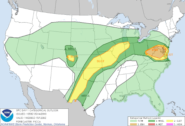
Day 1 Severe Weather Outlook
Day 1 Outlook Today and Tonight
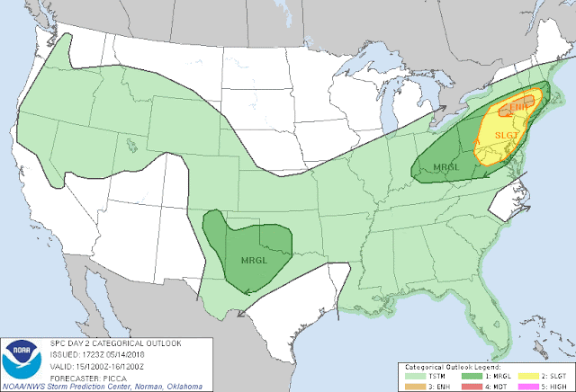
Day 2 Severe Weather Outlook
Day 2 Outlook May 15, 2018
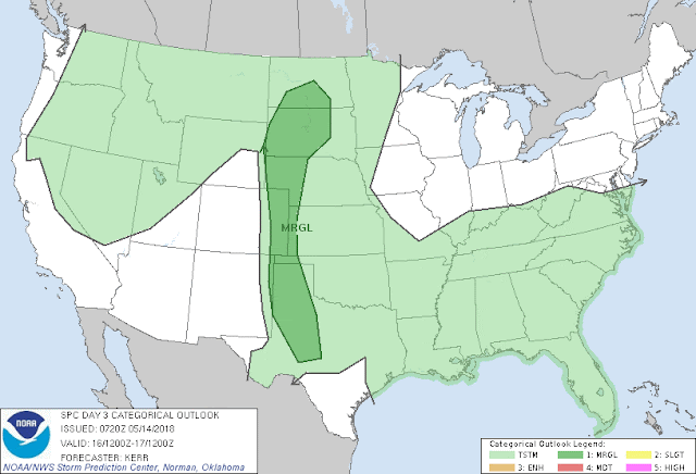
Day 3 Severe Weather Outlook
Day 3 Outlook

Sunday, May 13, 2018

Possible Hurricane for end of May 2018

Summer 2018 Forecast


Summer 2018 CAPE Anomaly

June 2018
June 2018 CAPE


July 2018 
July 2018 CAPE
August 2018

August 2018 CAPE

Average Jet Stream (200 MB Height Anomaly)

June 2018
June 2018 200 MB Mean Heights

July 2018
July 2018 200 MB Mean Heights


August 2018
August 2018 200 MB Mean Heights
From Andy's Weather Site
Written and Forecast By: Andrew D. (I am not a certified Meteorologist, I am only a Weather Guru with a SKYWARN Certificate By The NWS.)

Friday, April 13, 2018

Potential Dangerous Severe Weather For the Central Plans Friday

Potential Dangerous Severe Weather For the Central Plans Friday afternoon and evening. The NOAA Storm Prediction Center has an Enhanced Risk for Severe Weather for the Southern Iowa, Arkansas, Missouri, and  Louisiana. All modes of severe weather is likely, and I expect an Particular Dangerous Situation Watch for Eastern Oklahoma, Western Arkansas areas. Here has the potential for major tornado outbreak. 


Severe Weather Risk For Central Planes States
The Video... Note, I Recorded this video just before midnight. The timing for Severe Weather is Today into Tonight. Prime Time Around the dinner hours 4 to 9 PM CT.


Potential Dangerous Ice Storm For WNY And Flooding

Potential Dangerous Ice Storm and Flooding From Saturday, April 14 to Sunday, April 15, Freezing Rain for the Niagara Frontier area. We are looking at the possibility of a major ice storm Saturday Afternoon into Early Sunday Morning before changing to all rain Sunday Afternoon. Wide spread power outages are possible for much of this area. I expect a good amount of ice, anywhere from trace south of Buffalo Orchard Park to half inch for Tonawanda to Southern Niagara Falls to Lockport to Amherst. This area can get as much as an inch of solid ice. Winds will be from the East at 20 to 30 MPH gusts to near 40 MPH. This East Wind isn't good wind direction for trees as their root system isn't made for this direction, and the commendation of ice accumulations are sure concern for power outages. Places where I am most concern with power outages are Kenmore, Tonawanda, Amherst, Wheatfield, Grand Island, North Tonawanda areas. The video is a bit of a drag but I explain what is headed our direction. Followed by the ice, we are looking for a warm up. This warm up changes the rain fall to all rain on Sunday by mid-morning to afternoon. There is a potential for 2 inches plus of rain fall. This may pose a flood risk for areas streams and creeks where flood prone areas such West Senaca and Amherst. Turn Around Don't drown if you see a flooded road way. Report the flooded road to emergency officials. Also the heavy rains and flooding can be particular dangerous with the downed power lines and may also have issues with not seeing a flooded road especially in Amherst area. Stay tuned to your local TV and NWS Weather Radio. You can find more detailed weather from www.weather.gov/buf


The Video...


Thursday, March 1, 2018

Winter storm warning

Winter storm warning for Niagara Frontier of Western New York. Storm totals 8 to 14 in. Locally higher amount of snowfall possible. Winter storm warning is in effect from 4 p.m. today to 1 p.m. Friday. I will have my updated video blog shortly.

Winter Storm Watch

Winter storm watch continues to be in effect for Western New York from 9 p.m. Thursday March 1st through Friday evening March 2nd 2018. Winter storm total snowfall accumulation of up to 1 foot of snow and they have ears snow bans pending on elevation. My forecast is slightly different but within the guidelines of the National Weather Service in Buffalo. I am forecasting temperatures ranging from the lower 30s to Upper 20s with snowfall totals ranging from the upper 6 in 2 of to 14 in of snow. Areas north of Orchard Park New York will get higher amounts of snow then Southern Tier. My forecast video on on my forecast odds and current track of everything are below.