Weather Forecast For May 16, 2019
Written By Andrew Ditch
Written on: May 15, 2019 11:00 PM EDT
Updated: May 15, 2019 11:00 PM EDT
Today's Video
We will have one later on May 16, 2019 for an update around 7 PM EDT and will include the US Summer Outlook 2019.
Today's Written Article
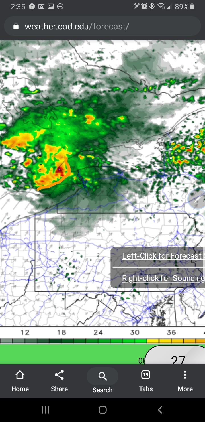
National Weather News
Short Range Forecast Discussion
NWS Weather Prediction Center College Park MD
401 PM EDT Wed May 15 2019
Valid 00Z Thu May 16 2019 - 00Z Sat May 18 2019
...Unsettled weather across much of the West, with heavy snowfall likely
for the highest elevations of the Sierra Nevada...
...Much above normal temperatures from the Central Plains to the Upper
Midwest on Thursday with near record highs possible...
...Stationary boundary draped from the Great Lakes to the Northern Plains
will support several days of locally heavy rainfall and potentially severe
thunderstorms...
...Multi-day severe weather event possible beginning Friday across the
Central U.S....
A strong upper level system arriving into the Western U.S. by tomorrow
morning will bring several days of unsettled weather to much of the the
Northwest and into the Rockies. Locally heavy to excessive rainfall is
possible, especially along the favored terrain of central/northern
California tonight, and the northern Rockies tomorrow. This system will
usher in much below normal temperatures (10 to 20+ degrees below average)
which will support moderate to heavy snowfall in some of the highest
elevations. The best chance for significant snows will be in the Sierra
Nevada where up to 2 feet of snow is possible and winter storm warnings
are in effect. Meanwhile ahead of the trough, daytime temperatures from
the Central Plains to the Upper Midwest will be very warm with daytime
highs as much as 20 to 25 degrees above normal and a handful of record or
near record highs possible.
Showers and thunderstorms developing across the Northern Plains this
afternoon will continue into tonight, with favorable conditions for
scattered strong to severe storms. Rain will expand eastward Thursday and
Friday into the Great Lakes and Midwest as a quasi-stationary boundary
sets up across the region. This boundary will provide focus for convection
and SPC has highlighted a narrow region along the front from the Central
Plains to the upper Ohio Valley within a slight risk for severe weather on
Thursday. Storms may contain locally heavy rainfall as well and WPC has
placed roughly this same region in a marginal risk for excessive
rainfall/flash flooding tomorrow.
As the Western U.S. trough kicks out into the Rockies on Friday, moist
southerly flow ahead of it will allow for the development of showers and
thunderstorms by Friday afternoon across much of the Plains. Conditions
will likely be favorable for strong to severe weather and heavy rainfall
from Texas to South Dakota where SPC has a large slight to enhanced risk
for severe thunderstorms. The best chance for excessive rain or flash
flooding by Friday will be for portions of the Northern Plains/Upper
Midwest where the stalled frontal boundary may provide additional focus
for multiple rounds of heavy rain. As the upper level system moves slowly
east into the weekend, this will kick-start what could be a several day
severe weather event across the Central states extending into the medium
range period.
Santorelli
Graphics available at www.wpc.ncep.noaa.gov/basicwx/basicwx_ndfd.php
Source: https://www.wpc.ncep.noaa.gov/discussions/hpcdiscussions.php?disc=pmdspd
Long Range Outlook For the USA
Prognostic Discussion for Monthly Outlook
NWS Climate Prediction Center College Park MD
300 PM EDT Tue Apr 30 2019
30-DAY OUTLOOK DISCUSSION FOR MAY 2019
The May 2019 outlook is updated at the end of the month considering the latest
forecast guidance for the month of May, including dynamical model forecasts for
May average temperature and accumulated precipitation from the NCEP Climate
Forecast System (CFS) and Global Ensemble Forecast System (GEFS), as well as
shorter range forecasts for week 1 and 2 from the NCEP GEFS, ECMWF, and
Canadian (ECCC) models, and guidance for weeks 3 and 4 from the CFS, ECMWF and
JMA models as well as the Subseasonal Experiment (SubX), a suite of
experimental and operational models, including the GEFS and ECCC models. The
background climate state is similar to that during the release of the prior May
outlook issued mid-April. El Nino conditions continue across the equatorial
Pacific, and are forecast to persist, likely into boreal summer. Equatorial
convection is enhanced near and just west of the International Date Line, and
upper-level anticyclonic circulations are observed to the north and south of
the equator. An MJO event developed recently, with enhanced convection
progressing eastward from the Indian Ocean to the Maritime Continent in the
last week. Dynamical models predict the progression of enhanced convection
across the Western Pacific in the next couple of weeks, where it may alter the
current El Nino influenced background state.
The temperature outlook indicates a larger area of enhanced probabilities of
below normal than the previous May outlook for much of the central CONUS east
of the Rockies. The area of likely below normal extends eastward to the western
Great Lakes, across the northern tier, and from the southern Rockies to western
Texas in the south. Enhanced probabilities of above normal temperatures
continue in the outlook for much of the eastern CONUS, while likely below
normal temperatures for the Northeast early in the month lead to reduced
probabilities for May above average temperatures for the region. Dynamical
model forecasts for increased probabilities of below normal temperatures over
the central CONUS and above normal temperatures over the Southeast in week 2
appear to be influenced by an active MJO over the Western Pacific. Above normal
temperatures continue to be most likely for Alaska and the northwest CONUS,
under predicted ridging, with the highest probabilities over western and
southern coastal areas of Alaska, where above average sea surface temperatures
persist. Decadal trends and dynamical model forecasts indicate a slightly
enhanced probability of above normal temperatures extending into parts of the
Southwest, west of the Four Corners region.
The precipitation outlook indicates substantially enhanced probabilities of
above normal from northeastern Texas into eastern Oklahoma and Kansas, as well
as the states of Arkansas and Missouri, where heavy precipitation is predicted
in dynamical model forecasts for the first week of May, and above normal
precipitation is likely throughout the month. The precipitation outlook for
above normal precipitation over much of the central CONUS and along the Gulf
Coast for May appears consistent with the current El Nino base state as
modified by MJO activity over the western Pacific. Dynamical model forecasts
predict enhanced probabilities of above normal precipitation for May from parts
of Central and Southern California eastward into the Central Rockies, and
across the Central and Southern Plains to the Mississippi Valley ahead of
troughing near the southwestern CONUS. The outlook indicates slightly enhanced
probabilities of above normal precipitation extending eastward to the
Appalachians and Florida, where dynamical model forecasts indicate below normal
precipitation in the first couple days of May and during the second half of the
month, but precipitation in model forecasts for week 2 increase the chances of
above normal for total monthly accumulated precipitation. The outlook indicates
equal chances of above and below normal precipitation for the Atlantic Coast
from Georgia to Maine. Dynamical model forecasts for May from the CFS and GEFS
continue to indicate enhanced probabilities of below normal precipitation for
the southern Alaska Panhandle and for much of the Pacific Northwest, under a
predicted mid-level ridge, while above normal precipitation is likely for much
of western Alaska, ahead of a predicted trough over the Aleutians.
The previous discussion for the May 2019 outlook, issued April 18, follows
below:
______________________________________________________________________________
The May 2019 outlook is informed by various forecast tools, both dynamical and
statistical, and is issued against a tropical background state that is largely
dominated by ENSO. El Nino conditions remain in place across the equatorial
Pacific, and are forecast to persist into boreal summer. Forecast tools that
contribute to the 0.5-month lead May 2019 outlook also vary in terms of their
characteristic time scales. Medium range dynamical models now extend into very
early May, and the the latest Weeks 3-4 guidance covers nearly the first half
of the month. These are in addition to guidance initialized during early April
for the entire month of May, which will tend to emphasize interannual
variability.
A good starting place for the May outlook is the calibrated NMME guidance. This
guidance is augmented by uncalibrated (but non-biased) forecast guidance from
the ECMWF and more recent runs of the CFS. Long-term trends play a role as
well. Given the time of year, antecedent soil moisture conditions play a role
by affecting the partitioning of incident solar radiation between sensible and
latent heating.
The temperature outlook consists of above-normal temperatures favored in an
arc-like region from parts of the West Coast, across the northern tier, and
over much of the eastern CONUS. Above-normal temperatures are strongly favored
over much of Alaska. Inspection of the forecast circulation for the CFS, for
example, reveals an ENSO-like wave dispersion featuring positive 200-hPa height
anomalies centered near and southeast of Hawaii, a weakness in above-normal
heights extending across parts of the eastern Pacific and southwestern North
America, and an anomalous 200-hPa ridge over west-central Canada extending
southeastward to the eastern CONUS. This general structure of the upper-level
height field is apparent in the latest Weeks 3-4 guidance and is broadly
consistent with ENSO regressions, but shifted 10-20 degrees longitude eastward
over the Pacific-North America domain. While this circulation pattern is
sufficient to explain the overall temperature pattern, there are some other
factors at play. High-amplitude soil moisture anomalies over much of the
central CONUS extending into the Midwest have a negative impact on temperature
during the warm season, and lead to a reduction in above-normal probabilities
relative to model guidance over parts of the Upper Midwest and Plains.
Below-normal temperatures are more likely over parts of the Southern Plains,
where forecast above-normal rainfall and wetter-than-normal soils support the
model consensus. Equal chances is depicted over a large region encompassing
much of the Southwest and parts of the Great Basin. Dynamical models are not in
good agreement here as the long-term warming trends and a relatively cool
interannual signal are destructively interfering.
The precipitation outlook is consistent with the aforementioned circulation
pattern; above-normal rainfall is more likely near and east of the anomalous
cyclonic upper-level circulation. This extends over much of the interior West,
High Plains, and Southern/Central Plains. There is an eastward extension at
very modest probabilities across the Gulf Coast and Deep South consistent with
ENSO and the dynamical model consensus. There is a small region extending from
the Pacific Northwest to the Alaska panhandle where below-normal precipitation
is more likely. This is likewise based on the model consensus and consistent
with long-term trends . There was some consideration of depicting below-normal
rainfall over parts of the Northeast and Great Lakes in accordance with the
latest Weeks 3-4 guidance and recent CFS runs. However, this is a low-skill
region in the hindcast and contrary to long-term trends , so equal chances is
depicted over the northeastern quarter of the CONUS.
FORECASTER: Dan Collins
The climatic normals are based on conditions between 1981 and 2010, following
the World Meteorological Organization convention of using the most recent 3
complete decades as the climate reference period. The probability anomalies
for temperature and precipitation based on these new normals better represent
shorter term climatic anomalies than the forecasts based on older normals.
The next monthly outlook...for Jun ... will be issued on Thu May 16 2019
These outlooks are based on departures from the 1981-2010 base period.
$$
Source: https://www.cpc.ncep.noaa.gov/products/predictions/long_range/fxus07.html
Buffalo, NY Weather News
Near Term Forecast - I am forecasting showers with an isolated thundershower mainly before 1 AM. Then becoming partly cloudy late. Tomorrow looks good day with good breeze from the West Southwest.
Long Term for WNY - I am forecasting above normal temperatures for end of this week into early next week. A bit of an active weather pattern setting up with increasing moisture and storms. Some of the storms as for right now are hinting to be strong side but way too far to forecast this. Stay tuned to Andy's Weather Site and The NWS Site at
www.weather.gov and
www.weather.gov/buf
Source: Andrew Ditch
Tonight
Showers, mainly before 11pm. Low around 44. Southwest wind 3 to 8 mph. Chance of precipitation is 80%. New precipitation amounts of less than a tenth of an inch possible.
Thursday
Partly sunny, with a high near 61. Light southwest wind becoming west 8 to 13 mph in the afternoon.
Thursday Night
Showers likely, mainly after 3am. Mostly cloudy, with a low around 55. South wind 6 to 13 mph. Chance of precipitation is 60%. New precipitation amounts of less than a tenth of an inch possible.
Friday
Showers likely, mainly before 8am. Cloudy through mid morning, then gradual clearing, with a high near 65. West wind 11 to 14 mph. Chance of precipitation is 60%. New precipitation amounts of less than a tenth of an inch possible.
Friday Night
Partly cloudy, with a low around 45. Northwest wind around 6 mph becoming calm after midnight.
Saturday
A slight chance of showers before 2pm. Partly sunny, with a high near 61. Chance of precipitation is 20%.
Saturday Night
A chance of showers after 2am. Mostly cloudy, with a low around 52. Chance of precipitation is 30%.
Sunday
A chance of showers before 8am, then a chance of showers and thunderstorms after noon. Partly sunny, with a high near 75. Chance of precipitation is 30%.
Sunday Night
A chance of showers. Mostly cloudy, with a low around 57. Chance of precipitation is 50%.
Monday
Showers likely, mainly before 11am. Mostly cloudy, with a high near 68. Chance of precipitation is 60%.
Monday Night
Partly cloudy, with a low around 51.
Tuesday
Partly sunny, with a high near 64.
Tuesday Night
Mostly cloudy, with a low around 52.
Wednesday
A chance of showers. Partly sunny, with a high near 71. Chance of precipitation is 30%.
Source: https://forecast.weather.gov/MapClick.php?textField1=42.940156&textField2=-78.722453
Todays Trivia!
None Today. A quick update on personal notes. Me still cant take care of myself because mix things of information from too many people trying to do their own thing to either get me proper help including autism testing for group home, or nothing because they are know it all doctors when they are only social workers for Adult Protection Services. Because the government in both family court and City Tonawanda Court states me being autism spectrum disorder and needing extra help in learning life's simple things like life skills. Yet I am smarter then they probably and still need a group home. Little do they know my primary doctor, People Center Services the Local OPWDD Autism Coordinator Services for my intake to link me to services, The Visiting Nurses feel I am needing autism testing and services such as group home. But the VNA Feels me developmental disabled and I was trying to say to my nurse before she left for the day yesterday, I dont want services because nothing wrong with me. She said because of my disability she cant let me cancel services unless a doctor says it or my guardianship says it which non of these say no I dont need it. She will listen to my recording of my APS Worker and her two rude supervisors who got me meltdown. I had a witness who is a autism behavior expert at a Autism Day Program who says if I am not autism then what is it? Is she wako or seeing different. She said what she says APS had a planned attack to bring me down in public and to embarrassed me. Well good thing I didnt feel this way because I dont understand language. I do know it was not nice and uncomfortable. Plus the tone of thier voices hurt my ears. All I am asking for is help with sensory problems, verbal communication both are reasons for my self injury meltdowns and that resulted in two arrests in 6 months. I so feel that if Forensics Doctors said me not able to make decision in court or medical I should be given a guardianship based on his writtings of Severe Autism, Sensory Processing Disorder and likely other Developmental Disabilities. Then to be going into ECMC to be told nothing wrong with me and a hospital I never had good luck with. I giving up because it is like me being nonverbal like before age 14 again. I do still need pictures to ask for things or to say my feelings or an ACC App like LetMeTalk for Android. I need OT, PT and Likely Speech Therapy. And aides who not here because me being in homeless. I cant even get help by needing help with diapers. Nothing wrong with me and been told I need diapers because of autism and sensory problems not being able to know when to go. But APS will be my reppayee not any other services for me. I am giving up on getting help I need or deserve. When I hear a friend who questioning my disability who worked in the nursing field of things telling me her 4 year old grand daughter can do things I cant do I cry. Then she says she knew I had issues but had to figure out who is lieing. Then to be told this person who I call Grandma because she is like it to me very caring and loving warm person like a Grandma who knows my needs who worked in Nursing Homes to tell me APS Tells her so many stories and me different ones to top things off. Then Me being told by my friend APS Tells her ... the APS Claims she cant even talk to her or have ever talked to her. All on audio recordings and made me want to cancel my autism testing on May 29. Then to be told nothing wrong with me I took off my diaper in my room and I later pee my pants and rug and socks and sneakers. I then texting a friend on Facebook and I pee myself and my weighed Blanket that is the only thing that relaxes me like my weighted compression vest. I tell APS Not to buy my diapers because I am faking it. I tell her to keep my money and food stamps because I wont be able to shop because I have sensory meltdowns in it even using ear muffs. I cant win with this. I have words and my words I have now are I want help I am smart show me. Teach me life skills and meltdown support. I have the right to treatment and the proper treatment. I have that autism behavior expert at Dunkin Donuts who said to me after I came back in because of a thunderstorm that could bring head banging meltdowns I am told by this lady I am asking for help and if I am not autism or developmental delay why is an autism program provider set up autism testing for May 29, and why do I stimm and have verbal language problems. I am smart and cant defend why I need help or defend my side of story and is big indicator for autism. She said my APS workers said I can use Uber to get to walmart 6 times to get things and me saying I cant shop for items I need most and even on a written list. I couldnt say I needed my whipes that took me 6 times to get them.Then to be shot down because I can use a computer, tablet and smart phone I am not autism. This autism person said like many people say Microsoft, EA Sports Games, and Video and Software Venders are only highering Autism People because We do It Writght and Do Work Well.
Please comment in the comments below.
Stay tuned to the answer to todays trivia question tomorrow!